The high places – poster
The high places – poster
Couldn't load pickup availability
Flat earth
Maps are a symbolic representation of a space, commonly countries, regions or towns. They seek to show a three-dimensional area on a flat surface, allowing humans to explain and navigate the world.
The land on paper
Evidence of humans abstracting the world onto a surface can be found as far back as early cave paintings and rock carvings. As civilisation became more and more advanced, so too did our cartographic abilities. Where once the oldest maps were of stars, now we are mapped from the stars – or at least from satellites in space.
About this piece
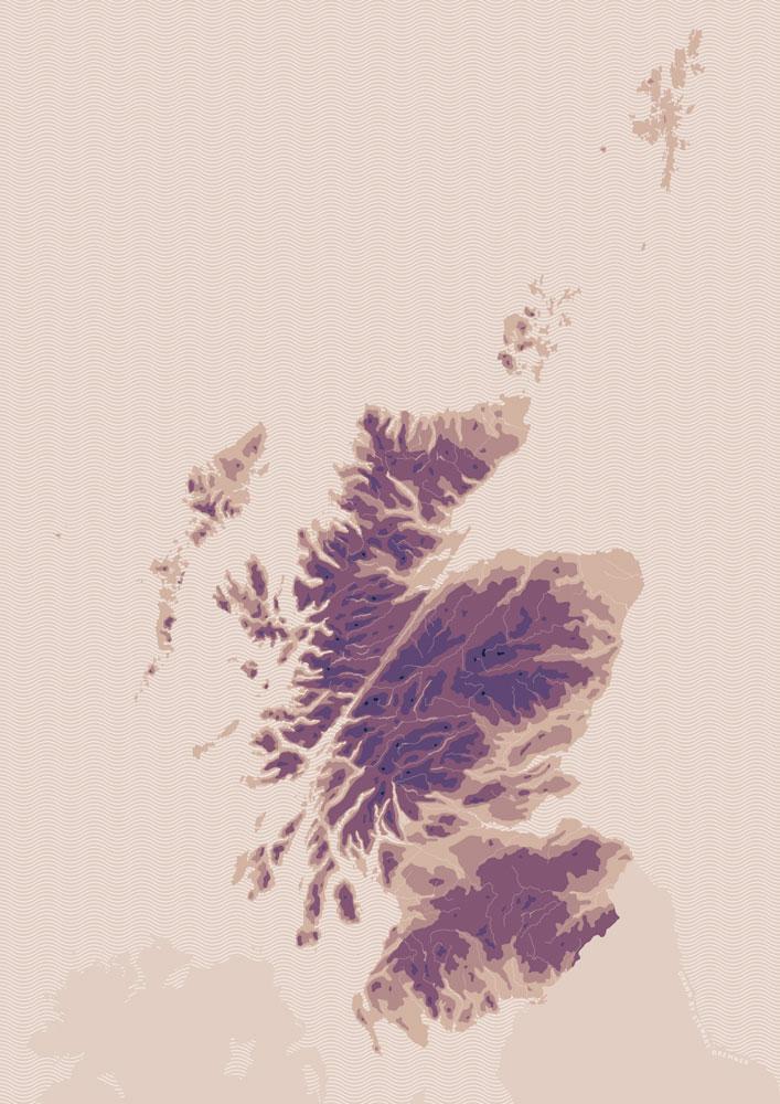
Scotland is known for its high places. From rolling hills to jagged mountains, few parts of the country are far from some magnificent vistas and every year thousands flock to take them in.
The artwork
Not many of us know the origins of our place names. This map, created along with the This contemporary graphic map uses rich brown tones to detail contoured areas that demonstrate just how much of Scotland is high land. The three main high areas are clearly separated by the giant slice of the Great Glen and, further south, the central belt.
Product details
- Paper size A3, 420x297mm
- 350gsm smooth white board
- Printed in Scotland on FSC® Mixed Sources paper
Shipping
Shipping
FREE SHIPPING on all orders over £50 (UK orders only).
Orders are posted every Friday
Items are printed to order, so expect your order to take around 7-14 days to arrive. Items sent within the UK are sent Second Class or Second Class Signed For on larger value orders. Royal Mail aim to deliver all second class items in three working days. Non-UK orders are sent by Royal Mail and their international partner carriers and will take approximately 14-21 days to arrive.
Shipping cost
Orders are sent Second Class or Second Class Signed for, depending on the order value. The shipping prices per order are the best I can estimate to cover the posting cost and packing materials.
Why I don't offer free shipping
As a small business, I source the products in my shop as locally and ethically as I can and I keep those products as affordably priced as possible when I sell them. Because of this – and because I pay my fair share of taxes – I cannot offer free shipping.
Shipping method
- A1 and A2 prints are posted rolled up in a mailing tube and are only ever combined in posting with A3 posters. Other items will be posted separately. If there is more than one print, they will be rolled together.
- A3 posters are posted rolled up in a mailing tube. If there is more than one poster, they will be rolled together. If your order includes additional items from below, the order will be posted in an A3 board-backed envelope, with the poster(s) bagged with an additional board back. If you order more than one poster and need extra sleeves and backs because they are presents, please note on the cart page how many extra are needed.
- Calendars are posted singly in a calendar envelope, apart from Beautiful Scotland calendars, which will be in an A4 board-backed envelope. Multiple calendars are sent in an A3 board-backed envelope.
- Mounted prints are posted in an A4 board-backed envelope for up to three, or in an A3 board-backed envelope for more. Any mounted print ordered with a calendar or A3 poster will be posted in an A3 board-backed envelope.
- Cards are sent in a A5 board-backed envelope for up to ten cards, or an A4 board-backed envelope for orders of over ten. Cards ordered with a calendar or A3 poster will be in an A3 board-backed envelope.
- Magnets are posted in an A6 board-backed envelope for up to three magnets or an A5 bubble envelope for four or more. Magnets ordered along with any of the items above will be in the relevant larger envelope.
Order more packing and posting materials
If you need extra envelopes or tubes, so that you can post items you order as gifts, you can buy some here.
Multiple discounts
Multiple discounts
You can make save money at Indy Prints when you buy three or more items, in the following groups:
Card and magnets
- Buy any 3 items and get 50p off your order – code: 50poff-3
- Buy any 6 items and get £1.50 off your order – code: 150poff-6
A3 posters, calendars and mounted prints
- Buy any 3 items and get £1.50 off your order – code: 150poff-3
- Buy any 6 items and get £4 off your order – code: 400poff-6
The savings are applied automatically at the checkout.
Note, this discount may not always apply to reduced price sale items.
Share
